
Results: Publications, Articels and Conferences
1. Herbst, Maximilian; Visscher, Jan; Lojek, Oliver; Schlurmann, Torsten
Structure-induced turbulent upwelling and sediment mobilization in a modified tidal inlet Journal Article
In: Continental Shelf Research, vol. 301, 2026.
Abstract | Links | BibTeX | Tags:
@article{nokey,
title = {Structure-induced turbulent upwelling and sediment mobilization in a modified tidal inlet},
author = {Maximilian Herbst and Jan Visscher and Oliver Lojek and Torsten Schlurmann},
doi = {10.1016/j.csr.2026.105718},
year = {2026},
date = {2026-10-00},
urldate = {2026-00-00},
journal = {Continental Shelf Research},
volume = {301},
abstract = {Coastal protection structures, such as groynes, are known to exert a lasting influence on tidal dynamics and sediment pathways of inlet systems. Yet, the complex fluid-structure interactions and system-scale implications remain insufficiently quantified. Aerial observation at the Harle inlet of the German Wadden Sea during highly energetic forcing by spring tide and intense storm conditions revealed pronounced turbidity patterns linked to the structural influence of a large-scale groyne. A unique field campaign combining aerial drone imagery, multiparameter profiling, and spatially paired ADCP measurements captured hydrodynamic, turbulence, and transport characteristics before, during, and after storm conditions. Thus, enabling isolation and assessment of the governing mechanisms, their recurrence, and their engineering implications. The groyne creates a submerged overflow, generating a near-bed roller in its wake that evokes a primary upwelling process. This upwelling drives turbulent structures, transporting available sediments to the surface, and rendering them visible in drone imagery. The Reynolds stress describing average fluxes of turbulent horizontal momentum by turbulent vertical motion (
) proved to be a robust proxy for the observed spatially extensive turbulent upwelling. Consistent detection of the hydraulic mechanisms and turbulent phases throughout the campaign indicates that the observed processes are recurring, structurally mediated features rather than storm-exclusive phenomena. Estimated sand transport capacities suggest that the fluid-structure interaction contributes a considerable fraction to the inlet's sediment budget. These findings emphasize the morphodynamic relevance of anthropogenic infrastructure in tidal inlets and highlight the critical need to account for long-term, system-wide consequences of these engineered structures in coastal protection strategies.},
keywords = {},
pubstate = {published},
tppubtype = {article}
}
Coastal protection structures, such as groynes, are known to exert a lasting influence on tidal dynamics and sediment pathways of inlet systems. Yet, the complex fluid-structure interactions and system-scale implications remain insufficiently quantified. Aerial observation at the Harle inlet of the German Wadden Sea during highly energetic forcing by spring tide and intense storm conditions revealed pronounced turbidity patterns linked to the structural influence of a large-scale groyne. A unique field campaign combining aerial drone imagery, multiparameter profiling, and spatially paired ADCP measurements captured hydrodynamic, turbulence, and transport characteristics before, during, and after storm conditions. Thus, enabling isolation and assessment of the governing mechanisms, their recurrence, and their engineering implications. The groyne creates a submerged overflow, generating a near-bed roller in its wake that evokes a primary upwelling process. This upwelling drives turbulent structures, transporting available sediments to the surface, and rendering them visible in drone imagery. The Reynolds stress describing average fluxes of turbulent horizontal momentum by turbulent vertical motion (
) proved to be a robust proxy for the observed spatially extensive turbulent upwelling. Consistent detection of the hydraulic mechanisms and turbulent phases throughout the campaign indicates that the observed processes are recurring, structurally mediated features rather than storm-exclusive phenomena. Estimated sand transport capacities suggest that the fluid-structure interaction contributes a considerable fraction to the inlet's sediment budget. These findings emphasize the morphodynamic relevance of anthropogenic infrastructure in tidal inlets and highlight the critical need to account for long-term, system-wide consequences of these engineered structures in coastal protection strategies.2. Schweiger, Constantin; Lojek, Oliver; Bölker, Thea; Mehrtens, Björn; Schürenkamp, David; Goseberg, Nils
Foredunes in front of secondary dunes exhibiting strong reduction potential in storm wave settings: A 2D experimental and numerical study Journal Article
In: Journal of Geophysical Research: Earth Surface, vol. 131, iss. 4, 2026.
@article{nokey,
title = {Foredunes in front of secondary dunes exhibiting strong reduction potential in storm wave settings: A 2D experimental and numerical study},
author = {Constantin Schweiger and Oliver Lojek and Thea Bölker and Björn Mehrtens and David Schürenkamp and Nils Goseberg},
doi = {10.1029/2025JF008756},
year = {2026},
date = {2026-04-22},
urldate = {2026-04-22},
journal = {Journal of Geophysical Research: Earth Surface},
volume = {131},
issue = {4},
keywords = {},
pubstate = {published},
tppubtype = {article}
}
3. Bruns, Ines; Bungenstock, Friederike; Karle, Martina
Storm surges along the prehistoric coast of northwest Germany Conference
16th International Scientific Wadden Sea Symposium (ISWSS), Groningen, Netherlands, 2025.
Abstract | Links | BibTeX | Tags:
@conference{nokey,
title = {Storm surges along the prehistoric coast of northwest Germany},
author = {Ines Bruns and Friederike Bungenstock and Martina Karle},
editor = {16th International Scientific Wadden Sea Symposium (ISWSS)},
doi = {https://doi.org/10.5281/zenodo.18494170},
year = {2025},
date = {2025-10-30},
urldate = {2025-10-30},
booktitle = {16th International Scientific Wadden Sea Symposium (ISWSS)},
address = {Groningen, Netherlands},
abstract = {Since the beginning of the Holocene, the rising sea level has resulted in a general retrogradational shift of the northwest German coastline. Additionally, storm surges influenced the paleo-coast and must be considered to better understand the landscape evolution in the region. Unlike to today’s highly engineered coastline, the prehistoric coast was un-diked and thus, it is assumed, that prehistoric storm surges had substantial different effects on the coastal environment. While storm surge deposits have been identified along the northwest German coast, they have not yet been systematically studied. The interdisciplinary project CoastAdapt aims to investigate the inland reach of prehistoric storm surges, the geological conditions that may have favoured inundation, and if storm surges triggered transgressions. The study focuses on cm-thick clastic layers known as “Klappklei,” found within Holocene peat horizons. “Klappklei” layers form only during high water levels and can therefore serve as valuable indicators of past storm surge events. We present a reconstruction of the spatial distribution of “Klappklei” across several Holocene time slices, along with estimates of associated inundation extent. The results are based on borehole archive data and updated sea-level reconstructions, complemented by a regional case study from the East Frisian coast.},
keywords = {},
pubstate = {published},
tppubtype = {conference}
}
Since the beginning of the Holocene, the rising sea level has resulted in a general retrogradational shift of the northwest German coastline. Additionally, storm surges influenced the paleo-coast and must be considered to better understand the landscape evolution in the region. Unlike to today’s highly engineered coastline, the prehistoric coast was un-diked and thus, it is assumed, that prehistoric storm surges had substantial different effects on the coastal environment. While storm surge deposits have been identified along the northwest German coast, they have not yet been systematically studied. The interdisciplinary project CoastAdapt aims to investigate the inland reach of prehistoric storm surges, the geological conditions that may have favoured inundation, and if storm surges triggered transgressions. The study focuses on cm-thick clastic layers known as “Klappklei,” found within Holocene peat horizons. “Klappklei” layers form only during high water levels and can therefore serve as valuable indicators of past storm surge events. We present a reconstruction of the spatial distribution of “Klappklei” across several Holocene time slices, along with estimates of associated inundation extent. The results are based on borehole archive data and updated sea-level reconstructions, complemented by a regional case study from the East Frisian coast.4. Bruns, Ines; Bungenstock, Friederike; Karle, Martina
2025.
Abstract | Links | BibTeX | Tags:
@conference{nokey,
title = {Storm surges and the un-diked coast: tracing prehistoric events in the Holocene sediment sequence of northwest Germany},
author = {Ines Bruns and Friederike Bungenstock and Martina Karle},
editor = {Geo4Göttingen 2025 (DGGV, DGM, DGGM, PalGes Annual Meeting)},
doi = {10.48380/nfp1-kn63},
year = {2025},
date = {2025-09-17},
urldate = {2025-09-17},
journal = {Geo4Göttingen 2025 (DGGV, DGM, DGGM, PalGes Annual Meeting)},
abstract = {The interdisciplinary project CoastAdapt aims to close this gap by investigating the inland reach of prehistoric storm surges, the geological conditions that may have favoured inundation, and whether some transgressions attributed to sea-level rise may have actually been storm-driven. Focus lies on cm-thick clastic layers (known as Klappklei) found within Holocene peat. These layers form when storm surges temporarily disturb coastal peat horizons, allowing fine sediments to be deposited and preserved within the peat horizon. As Klappklei only forms during high water levels, it is considered to be a valuable marker of prehistoric storm surge activity.
We present a comprehensive mapping of these deposits for different time intervals of the Holocene, alongside estimates of associated inundation extent. The results are based on borehole archive data, integrated with updated sea-level reconstructions. A preliminary regional case study from the East Frisian coast provides new insights into landscape development and effects of storm surge events.},
keywords = {},
pubstate = {published},
tppubtype = {conference}
}
The interdisciplinary project CoastAdapt aims to close this gap by investigating the inland reach of prehistoric storm surges, the geological conditions that may have favoured inundation, and whether some transgressions attributed to sea-level rise may have actually been storm-driven. Focus lies on cm-thick clastic layers (known as Klappklei) found within Holocene peat. These layers form when storm surges temporarily disturb coastal peat horizons, allowing fine sediments to be deposited and preserved within the peat horizon. As Klappklei only forms during high water levels, it is considered to be a valuable marker of prehistoric storm surge activity.
We present a comprehensive mapping of these deposits for different time intervals of the Holocene, alongside estimates of associated inundation extent. The results are based on borehole archive data, integrated with updated sea-level reconstructions. A preliminary regional case study from the East Frisian coast provides new insights into landscape development and effects of storm surge events.5. Marx, Carlotta; Lechtenberg, Julia; Lansing, Sophia; Dieckhoff, Martin Schulze; Balke, Thorsten; Isermann, Maike
Vegetation-ecological development of artificial dunes on Spiekeroog, North-West Germany Conference
Sand Dune and Shingle Network Conference, Liverpool Hope University, 2025.
BibTeX | Tags:
@conference{nokey,
title = {Vegetation-ecological development of artificial dunes on Spiekeroog, North-West Germany},
author = {Carlotta Marx and Julia Lechtenberg and Sophia Lansing and Martin Schulze Dieckhoff and Thorsten Balke and Maike Isermann},
editor = {Sand Dune and Shingle Network Conference},
year = {2025},
date = {2025-09-16},
urldate = {2025-09-16},
booktitle = {Sand Dune and Shingle Network Conference},
address = {Liverpool Hope University},
keywords = {},
pubstate = {published},
tppubtype = {conference}
}
6. Marx, Carlotta; Lechtenberg, Julia; Lansing, Sophia; Dieckhoff, Martin Schulze; Balke, Thorsten; Isermann, Maike
Poster: Differences in vegetation ecology between natural and artificial dunes on Spiekeroog Conference
54th Annual Meeting of the Ecological Society of Germany, Austria and Switzerland, GfÖ, University of Würzburg, 2025.
BibTeX | Tags:
@conference{nokey,
title = {Poster: Differences in vegetation ecology between natural and artificial dunes on Spiekeroog},
author = {Carlotta Marx and Julia Lechtenberg and Sophia Lansing and Martin Schulze Dieckhoff and Thorsten Balke and Maike Isermann },
editor = {Ecological Society of Germany, Austria and Switzerland, GfÖ},
year = {2025},
date = {2025-09-01},
urldate = {2025-09-01},
booktitle = {54th Annual Meeting of the Ecological Society of Germany, Austria and Switzerland, GfÖ},
address = {University of Würzburg},
keywords = {},
pubstate = {published},
tppubtype = {conference}
}
7.
Schweiger, Constantin
The CoastAdapt project Conference
41. Annual Meeting of the Working Group on Geography of the Seas and Coasts
, vol. 41., Arbeitskreises der Geographie der Meere und Küsten NiHK, ICBM Wilhelmshaven, 2025.
@conference{nokey,
title = {The CoastAdapt project},
author = {Constantin Schweiger},
editor = {Working Group on Geography of the Seas and Coasts},
year = {2025},
date = {2025-05-22},
urldate = {2025-05-22},
booktitle = {41. Annual Meeting of the Working Group on Geography of the Seas and Coasts
},
volume = {41.},
address = {Wilhelmshaven},
organization = {NiHK, ICBM},
series = {Arbeitskreises der Geographie der Meere und Küsten},
abstract = {The challenge of social, economic and technical adaptation measures in coastal areas is more evident in the present day than it was at the end of the last millennium. Accelerated sea level rise (Steffelbauer et al. 2022) and associated changes (Jordan et al. 2021), such as an increasing frequency and intensity of extreme hydrodynamic events (Vitousek et al. 2017), are direct effects of climate change, in some cases exacerbated by anthropogenic use (Church et al. 2013; Otto et al. 2022). A recent study also reveals that global ocean warming and the annual rate of warming could once again set new records for the year 2024 (Cheng et al. 2025). It can be extrapolated from this that the already devastating effects of climate change will lead to further intensifying conflicts in the areas of socio-economics, coastal protection, water management, sustainable development and nature conservation. This indicates that the coastal landscape is likely to encounter significant challenges and necessitate the implementation of adaptive management strategies for the coastal area. These strategies should encompass continuous social, economic, and technical adaptation measures, employing an interdisciplinary approach and ensuring the ongoing involvement of relevant stakeholders.
In the “CoastAdapt” project, these challenges are to be met with a knowledge and innovation ecosystem "Coastal Engineering and Coastal Research", which pursues the overarching goal of strengthening interdisciplinary cooperation in the Lower Saxony research landscape through structural networking and bundling of research, teaching and transfer with the interdisciplinary integration of universities, non-university institutions, specialist authorities, associations of all kinds, clubs, commercial enterprises and civil society. The presentation will provide a comprehensive overview of the project's overarching objectives, with a particular emphasis on the interdisciplinary nature of the initiative. Additionally, it will delve into the research activities that are targeted from a coastal engineering perspective.},
keywords = {},
pubstate = {published},
tppubtype = {conference}
}
The challenge of social, economic and technical adaptation measures in coastal areas is more evident in the present day than it was at the end of the last millennium. Accelerated sea level rise (Steffelbauer et al. 2022) and associated changes (Jordan et al. 2021), such as an increasing frequency and intensity of extreme hydrodynamic events (Vitousek et al. 2017), are direct effects of climate change, in some cases exacerbated by anthropogenic use (Church et al. 2013; Otto et al. 2022). A recent study also reveals that global ocean warming and the annual rate of warming could once again set new records for the year 2024 (Cheng et al. 2025). It can be extrapolated from this that the already devastating effects of climate change will lead to further intensifying conflicts in the areas of socio-economics, coastal protection, water management, sustainable development and nature conservation. This indicates that the coastal landscape is likely to encounter significant challenges and necessitate the implementation of adaptive management strategies for the coastal area. These strategies should encompass continuous social, economic, and technical adaptation measures, employing an interdisciplinary approach and ensuring the ongoing involvement of relevant stakeholders.
In the “CoastAdapt” project, these challenges are to be met with a knowledge and innovation ecosystem "Coastal Engineering and Coastal Research", which pursues the overarching goal of strengthening interdisciplinary cooperation in the Lower Saxony research landscape through structural networking and bundling of research, teaching and transfer with the interdisciplinary integration of universities, non-university institutions, specialist authorities, associations of all kinds, clubs, commercial enterprises and civil society. The presentation will provide a comprehensive overview of the project's overarching objectives, with a particular emphasis on the interdisciplinary nature of the initiative. Additionally, it will delve into the research activities that are targeted from a coastal engineering perspective.8.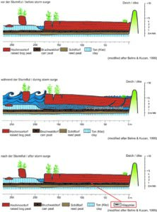
Bruns, Ines; Bungenstock, Friederike; Karle, Martina
Prehistoric storm surges in northwest Germany – record in the Holocene sediment sequence and effects on the un-diked coast Conference
41. Annual Meeting of the Working Group on Geography of the Seas and Coasts, vol. 41., Arbeitskreises der Geographie der Meere und Küsten NihK, ICBM, Wilhelmshaven, 2025.
@conference{nokey,
title = {Prehistoric storm surges in northwest Germany – record in the Holocene sediment sequence and effects on the un-diked coast},
author = {Ines Bruns and Friederike Bungenstock and Martina Karle},
editor = {Working Group on Geography of the Seas and Coasts},
year = {2025},
date = {2025-05-22},
urldate = {2025-05-22},
booktitle = {41. Annual Meeting of the Working Group on Geography of the Seas and Coasts},
volume = {41.},
pages = {1-36 | 6},
publisher = {NihK, ICBM},
address = {Wilhelmshaven},
organization = {Arbeitskreises der Geographie der Meere und Küsten},
abstract = {Since the beginning of the Holocene, the northwest German coast has been shaped by the rising sea level, resulting in a general retrogradational shift of the coastline. Accordingly, the Holocene sedimentary sequence comprises peat layers, brackish-lagoonal, and marine deposits. In addition to gradual changes, extreme events such as storm surges have contributed to coastal development and must be considered to better understand the region’s landscape evolution.
In contrast to the modern coast, which is strongly influenced by human-made constructions, the paleo-coast was un-diked. Therefore, it can be assumed, that prehistoric storm surges had different effects on the coastal environment at the time. Storm surge deposits have been documented along the East Frisian coast and the Ems-Dollard estuary. However, they have not been systematically investigated so far. The short-term and long-term effects of storm surges remain poorly understood. Key questions are: How far did storm surge waters inundate inland? Were certain areas especially prone to inundation and erosion? And might past storm surges have triggered transgressions?
The interdisciplinary project CoastAdapt addresses these questions through insights from sedimentological archives and paleo-landscape reconstructions. Our focus lies on thin (mm to cm) clastic layers embedded within Holocene peat horizons — known as Klappklei. These deposits form during severe storm events, when the seawater reaches coastal peatlands, causing the upper part of the peat to temporarily uplift and allowing fine-grained sediments to enter the resulting gap. As the peat resettles after the storm, the sediment becomes preserved, creating a clear, interpretable record of storm surge history.
We present a first overview of the spatial and temporal distribution of Klappklei deposits and associated inundation extent of prehistoric storm surges. These initial results are based on extensive analyses of borehole archive data, integrated with updated sea-level reconstructions for the northwest German coast. Preliminary insights also highlight areas that appear particularly vulnerable to inundation.},
keywords = {},
pubstate = {published},
tppubtype = {conference}
}
Since the beginning of the Holocene, the northwest German coast has been shaped by the rising sea level, resulting in a general retrogradational shift of the coastline. Accordingly, the Holocene sedimentary sequence comprises peat layers, brackish-lagoonal, and marine deposits. In addition to gradual changes, extreme events such as storm surges have contributed to coastal development and must be considered to better understand the region’s landscape evolution.
In contrast to the modern coast, which is strongly influenced by human-made constructions, the paleo-coast was un-diked. Therefore, it can be assumed, that prehistoric storm surges had different effects on the coastal environment at the time. Storm surge deposits have been documented along the East Frisian coast and the Ems-Dollard estuary. However, they have not been systematically investigated so far. The short-term and long-term effects of storm surges remain poorly understood. Key questions are: How far did storm surge waters inundate inland? Were certain areas especially prone to inundation and erosion? And might past storm surges have triggered transgressions?
The interdisciplinary project CoastAdapt addresses these questions through insights from sedimentological archives and paleo-landscape reconstructions. Our focus lies on thin (mm to cm) clastic layers embedded within Holocene peat horizons — known as Klappklei. These deposits form during severe storm events, when the seawater reaches coastal peatlands, causing the upper part of the peat to temporarily uplift and allowing fine-grained sediments to enter the resulting gap. As the peat resettles after the storm, the sediment becomes preserved, creating a clear, interpretable record of storm surge history.
We present a first overview of the spatial and temporal distribution of Klappklei deposits and associated inundation extent of prehistoric storm surges. These initial results are based on extensive analyses of borehole archive data, integrated with updated sea-level reconstructions for the northwest German coast. Preliminary insights also highlight areas that appear particularly vulnerable to inundation.9.
Bölker, Thea; Lojek, Oliver; Schweiger, Constantin; Goseberg, Nils
Analysis of coastal dune structure and vegetation patterns: An extensive field campaign on Langeoog Conference
41. Annual Meeting of the Working Group on Geography of the Seas and Coasts, vol. 41., Arbeitskreises der Geographie der Meere und Küsten NiHK, ICBM Wilhelmshaven, 2025.
@conference{nokey,
title = {Analysis of coastal dune structure and vegetation patterns: An extensive field campaign on Langeoog},
author = {Thea Bölker and Oliver Lojek and Constantin Schweiger and Nils Goseberg},
editor = {Working Group on Geography of the Seas and Coasts},
year = {2025},
date = {2025-05-22},
urldate = {2025-05-22},
booktitle = {41. Annual Meeting of the Working Group on Geography of the Seas and Coasts},
volume = {41.},
pages = {1-33 | 4},
address = {Wilhelmshaven},
organization = {NiHK, ICBM},
series = {Arbeitskreises der Geographie der Meere und Küsten},
abstract = {Coastal dunes provide a variety of ecosystem services, including biodiversity, freshwater supply, and storm surge protection, making them an integral part of coastal ecosystems. However, rising sea levels as well as changes in wave and wind conditions due to climate change are increasing the pressure on coastal systems. From an engineering point of view, the focus is on protection against storm surges, with dune erosion processes often being studied in physical experiments. To ensure a high reliability of the model, it is crucial to first capture the dunes as realistically and thoroughly as possible. Therefore, a field campaign in March 2025 on the East Frisian Island Langeoog, Lower Saxony, Germany is conducted aiming to provide valuable insight in the internal structure of the dunes and in the evolving vegetation patterns on the dunes. This campaign will involve a wide variety of measurements, employing both established and novel techniques. A drone survey will capture vegetation patterns, coverage and the topography of the dune landscape, by deriving digital elevation data through structure from motion. Additionally, a ground-penetrating radar (GPR) will be utilized to detect internal physical boundaries through the visualization of contrasts in electromagnetic properties to draw conclusions about the layering of the sediment, the moisture content, grain size, porosity and the presence of roots. Complementary measurements will be conducted to gather soil and vegetation parameters, aiding in the calibration and interpretation of the spatial data obtained from the drone surveys and the GPR. The study aims to identify potential correlations among the various measured parameters, as well as between these parameters and specific constraints, such as distance from and orientation to the shoreline, to enhance physical modeling. Preliminary results of the field campaign will be presented, accompanied by a discussion of their potential implications for future research and model building.},
keywords = {},
pubstate = {published},
tppubtype = {conference}
}
Coastal dunes provide a variety of ecosystem services, including biodiversity, freshwater supply, and storm surge protection, making them an integral part of coastal ecosystems. However, rising sea levels as well as changes in wave and wind conditions due to climate change are increasing the pressure on coastal systems. From an engineering point of view, the focus is on protection against storm surges, with dune erosion processes often being studied in physical experiments. To ensure a high reliability of the model, it is crucial to first capture the dunes as realistically and thoroughly as possible. Therefore, a field campaign in March 2025 on the East Frisian Island Langeoog, Lower Saxony, Germany is conducted aiming to provide valuable insight in the internal structure of the dunes and in the evolving vegetation patterns on the dunes. This campaign will involve a wide variety of measurements, employing both established and novel techniques. A drone survey will capture vegetation patterns, coverage and the topography of the dune landscape, by deriving digital elevation data through structure from motion. Additionally, a ground-penetrating radar (GPR) will be utilized to detect internal physical boundaries through the visualization of contrasts in electromagnetic properties to draw conclusions about the layering of the sediment, the moisture content, grain size, porosity and the presence of roots. Complementary measurements will be conducted to gather soil and vegetation parameters, aiding in the calibration and interpretation of the spatial data obtained from the drone surveys and the GPR. The study aims to identify potential correlations among the various measured parameters, as well as between these parameters and specific constraints, such as distance from and orientation to the shoreline, to enhance physical modeling. Preliminary results of the field campaign will be presented, accompanied by a discussion of their potential implications for future research and model building.10.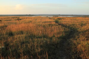
Hackett, Isabel; Goseberg, Nils; Schweiger, Constantin; Lojek, Oliver; Karle, Martina; Bungenstock, Friederike; Bruns, Ines
Influence of Shifting Land Management and Salt Marsh Vegetation Composition on Wave Attenuation Through the Late Holocene Conference
41. Annual Meeting of the Working Group on Geography of the Seas and Coasts, vol. 41., Arbeitskreises der Geographie der Meere und Küsten NiHK, ICBM Wilhelmshaven, 2025.
@conference{nokey,
title = {Influence of Shifting Land Management and Salt Marsh Vegetation Composition on Wave Attenuation Through the Late Holocene},
author = {Isabel Hackett and Nils Goseberg and Constantin Schweiger and Oliver Lojek and Martina Karle and Friederike Bungenstock and Ines Bruns},
editor = {Working Group on Geography of the Seas and Coasts},
year = {2025},
date = {2025-05-22},
urldate = {2025-05-22},
booktitle = {41. Annual Meeting of the Working Group on Geography of the Seas and Coasts},
volume = {41.},
pages = {1 - 33 | 12},
address = {Wilhelmshaven},
organization = {NiHK, ICBM},
series = {Arbeitskreises der Geographie der Meere und Küsten},
abstract = {Salt marshes are rich and diverse environments, which when functioning and protected, have the capacity to improve the health of both the terrestrial and marine environments they link. Along the North Sea coastline, and other areas vulnerable to storm surge floods and increasing sea levels, the wave attenuating capacity of salt marshes is of critical importance. Wave attenuation by salt marsh vegetation occurs through long term sediment accumulation and friction. In this study I analyze historical vegetation composition evidenced in sediment cores in the Krummhörn region along the North Sea coastline in Lower Saxony, in order to model salt marsh wave attenuation across varying periods of land-use and salt marsh extent. The prevalent species types, such as Juncus gerardii, Suaeda maritima, Salicornia europeae, and Spergularia salina, occupy distinct zones of the salt marsh and impact the tidal flow in differing ways. While sea level rise is currently accelerating faster than we have seen in the past 3,000 years of human history (Jelgersma, 1971), it is not a new phenomena, with the entirety of the Holocene epoch defined by rising levels. Analyzing the environmental history of the North Sea coastline allows us to consider future developments and potential paths towards more adaptable coastlines. With a focus on differing spatial extents and vegetation compositions, tidal damping under varying historical conditions will be modeled using Delft3D.},
keywords = {},
pubstate = {published},
tppubtype = {conference}
}
Salt marshes are rich and diverse environments, which when functioning and protected, have the capacity to improve the health of both the terrestrial and marine environments they link. Along the North Sea coastline, and other areas vulnerable to storm surge floods and increasing sea levels, the wave attenuating capacity of salt marshes is of critical importance. Wave attenuation by salt marsh vegetation occurs through long term sediment accumulation and friction. In this study I analyze historical vegetation composition evidenced in sediment cores in the Krummhörn region along the North Sea coastline in Lower Saxony, in order to model salt marsh wave attenuation across varying periods of land-use and salt marsh extent. The prevalent species types, such as Juncus gerardii, Suaeda maritima, Salicornia europeae, and Spergularia salina, occupy distinct zones of the salt marsh and impact the tidal flow in differing ways. While sea level rise is currently accelerating faster than we have seen in the past 3,000 years of human history (Jelgersma, 1971), it is not a new phenomena, with the entirety of the Holocene epoch defined by rising levels. Analyzing the environmental history of the North Sea coastline allows us to consider future developments and potential paths towards more adaptable coastlines. With a focus on differing spatial extents and vegetation compositions, tidal damping under varying historical conditions will be modeled using Delft3D.11.
Lechtenberg, Julia; Balke, Thorsten; Isermann, Maike
Ecological functions and processes of natural and anthropogenically influenced dunes Conference
41. Annual Meeting of the Working Group on Geography of the Seas and Coasts, vol. 41, Arbeitskreises der Geographie der Meere und Küsten NiHK, ICBM Wilhelmshaven, 2025.
@conference{nokeye,
title = {Ecological functions and processes of natural and anthropogenically influenced dunes},
author = {Julia Lechtenberg and Thorsten Balke and Maike Isermann},
editor = {Working Group on Geography of the Seas and Coasts},
year = {2025},
date = {2025-05-22},
urldate = {2025-05-22},
booktitle = {41. Annual Meeting of the Working Group on Geography of the Seas and Coasts},
volume = {41},
address = {Wilhelmshaven},
organization = {NiHK, ICBM},
series = {Arbeitskreises der Geographie der Meere und Küsten},
abstract = {In the face of rising sea levels due to climate change, future-oriented flood protection is becoming increasingly important. Recently, the potential for naturally designed protective dunes has gained attention, with natural dunes recognized as providers of the ecosystem service "flood protection." However, the geomorphological-ecological differences between engineered protective dunes and natural dunes and how these affect ecosystem services, remain insufficiently understood. We aim to investigate the functioning and importance of (natural) dune ecosystems in coastal protection and to identify how their protective capacity can be maintained or optimized while conserving their ecological value. We will extract information about historical coastal dune protections from arial pictures, historical maps and planning permissions as well as measurements info-flyers from the NLWKN. Then we will survey engineered protective dunes and adjacent natural dunes differing in location, geomorphology, sediment balance and age to be able to compare the current state of both dune types. We will conduct vegetation surveys of vascular plants, mosses and lichens and take soil samples across transects spanning from embryonic dunes to brown dunes. We expect to obtain insights on the temporal development of abiotic and biotic factors of coastal protection dunes, which can then be used to assess the nature conservation and engineering status of natural dunes and coastal protection dunes and to find options for the future use of natural dynamics in coastal protection dunes.},
keywords = {},
pubstate = {published},
tppubtype = {conference}
}
In the face of rising sea levels due to climate change, future-oriented flood protection is becoming increasingly important. Recently, the potential for naturally designed protective dunes has gained attention, with natural dunes recognized as providers of the ecosystem service "flood protection." However, the geomorphological-ecological differences between engineered protective dunes and natural dunes and how these affect ecosystem services, remain insufficiently understood. We aim to investigate the functioning and importance of (natural) dune ecosystems in coastal protection and to identify how their protective capacity can be maintained or optimized while conserving their ecological value. We will extract information about historical coastal dune protections from arial pictures, historical maps and planning permissions as well as measurements info-flyers from the NLWKN. Then we will survey engineered protective dunes and adjacent natural dunes differing in location, geomorphology, sediment balance and age to be able to compare the current state of both dune types. We will conduct vegetation surveys of vascular plants, mosses and lichens and take soil samples across transects spanning from embryonic dunes to brown dunes. We expect to obtain insights on the temporal development of abiotic and biotic factors of coastal protection dunes, which can then be used to assess the nature conservation and engineering status of natural dunes and coastal protection dunes and to find options for the future use of natural dynamics in coastal protection dunes.12.
Merz, Nina; Vovides, Alejandra G; Balke, Thorsten
Monitoring tidal hydrology within saltmarsh vegetation to detect current velocity attenuation using the Mini Buoy Conference
41. Annual Meeting of the Working Group on Geography of the Seas and Coasts, vol. 41, Arbeitskreises der Geographie der Meere und Küsten NiHK, ICBM Wilhelmshaven, 2025.
@conference{nokeyf,
title = {Monitoring tidal hydrology within saltmarsh vegetation to detect current velocity attenuation using the Mini Buoy},
author = {Nina Merz and Alejandra G Vovides and Thorsten Balke},
editor = {Working Group on Geography of the Seas and Coasts},
year = {2025},
date = {2025-05-22},
urldate = {2025-05-22},
booktitle = {41. Annual Meeting of the Working Group on Geography of the Seas and Coasts},
journal = {41. Annual Meeting of the Working Group on Geography of the Seas and Coasts},
volume = {41},
address = {Wilhelmshaven},
organization = {NiHK, ICBM},
series = {Arbeitskreises der Geographie der Meere und Küsten},
abstract = {Growing coastal populations are vulnerable to the effects of climate change and sea level rise. With the increasing intensity and frequency of storms, there are growing concerns for our ability to adapt to- and mitigate climate change impacts. Coastal habitats, such as saltmarshes, are therefore increasingly valued for their contribution to coastal protection through their ability to dissipate wave- and current velocity. These essential ecosystem services have been provided by saltmarshes globally. There is a growing interest in implementing a nature-based approach to coastal defence by integrating natural ecosystems such as saltmarshes, however, this is hindered by gaps in our knowledge concerning biophysical feedbacks that inform ecosystem service delivery. This knowledge is essential for accurately and reliably predicting risk reduction capacity. Therefore, developing a tool for long-term hydrodynamic monitoring, quantifying the current velocity (Cv) attenuation effects of saltmarsh vegetation, and understanding how plant traits can impact Cv attenuation capacity are critical steps towards the implementation of nature-based solutions for coastal protection.
The Cv attenuation in two common saltmarsh species (Bolboschoenus maritimus and Phragmites australis) was quantified using a novel low-cost method (the Mini-Buoy). Cv attenuation was measured by comparing Cv measured at the edge and 5m into the vegetation from shoot emergence in May to peak biomass in September, 2023. Vegetation surveys were carried out to associate plant traits (i.e., stem density, stem diameter and plat height) with their hydrodynamic attenuation effect. Also, two models of the Mini Buoy (Pendant and the B4+) were compared against each other to determine which was better suited for deployment within saltmarsh vegetation. Our study found that the Pendant Mini Buoy was the better model for hydrodynamic monitoring within the canopy and for quantification of Cv attenuation in shallow, low-energy conditions. Plant morphology gradients were observed in both B. maritimus and P. australis where slenderness of the plants increased landward of the seaward boundary. Between the two species, significant differences in morphology and attenuation capacity were observed. Lower stem density and frontal surface area (FSA) was consistently observed in P. australis which was also found to develop in lower hydrodynamic energy areas, suggesting that P. australis is more vulnerable to hydrodynamic forcing. Overall, B. maritimus (maximum Cv reduction of ~60%) was found to be more effective at reducing Cv than P. australis (maximum Cv reduction of ~40%).},
keywords = {},
pubstate = {published},
tppubtype = {conference}
}
Growing coastal populations are vulnerable to the effects of climate change and sea level rise. With the increasing intensity and frequency of storms, there are growing concerns for our ability to adapt to- and mitigate climate change impacts. Coastal habitats, such as saltmarshes, are therefore increasingly valued for their contribution to coastal protection through their ability to dissipate wave- and current velocity. These essential ecosystem services have been provided by saltmarshes globally. There is a growing interest in implementing a nature-based approach to coastal defence by integrating natural ecosystems such as saltmarshes, however, this is hindered by gaps in our knowledge concerning biophysical feedbacks that inform ecosystem service delivery. This knowledge is essential for accurately and reliably predicting risk reduction capacity. Therefore, developing a tool for long-term hydrodynamic monitoring, quantifying the current velocity (Cv) attenuation effects of saltmarsh vegetation, and understanding how plant traits can impact Cv attenuation capacity are critical steps towards the implementation of nature-based solutions for coastal protection.
The Cv attenuation in two common saltmarsh species (Bolboschoenus maritimus and Phragmites australis) was quantified using a novel low-cost method (the Mini-Buoy). Cv attenuation was measured by comparing Cv measured at the edge and 5m into the vegetation from shoot emergence in May to peak biomass in September, 2023. Vegetation surveys were carried out to associate plant traits (i.e., stem density, stem diameter and plat height) with their hydrodynamic attenuation effect. Also, two models of the Mini Buoy (Pendant and the B4+) were compared against each other to determine which was better suited for deployment within saltmarsh vegetation. Our study found that the Pendant Mini Buoy was the better model for hydrodynamic monitoring within the canopy and for quantification of Cv attenuation in shallow, low-energy conditions. Plant morphology gradients were observed in both B. maritimus and P. australis where slenderness of the plants increased landward of the seaward boundary. Between the two species, significant differences in morphology and attenuation capacity were observed. Lower stem density and frontal surface area (FSA) was consistently observed in P. australis which was also found to develop in lower hydrodynamic energy areas, suggesting that P. australis is more vulnerable to hydrodynamic forcing. Overall, B. maritimus (maximum Cv reduction of ~60%) was found to be more effective at reducing Cv than P. australis (maximum Cv reduction of ~40%).13.
Rodermund, Henrike; Blum, Holger; Thorenz, Frank; Schürenkamp, David; Goseberg, Nils
Investigation of erosion protection of salt marsh cliffs in the interdisciplinary project CoastAdapt Conference
41. Annual Meeting of the Working Group on Geography of the Seas and Coasts, vol. 41, Arbeitskreises der Geographie der Meere und Küsten NiHK, ICBM Wilhelmshaven, 2025.
@conference{nokeyg,
title = {Investigation of erosion protection of salt marsh cliffs in the interdisciplinary project CoastAdapt},
author = {Henrike Rodermund and Holger Blum and Frank Thorenz and David Schürenkamp and Nils Goseberg},
editor = {Working Group on Geography of the Seas and Coasts},
year = {2025},
date = {2025-05-22},
urldate = {2025-05-22},
booktitle = {41. Annual Meeting of the Working Group on Geography of the Seas and Coasts},
volume = {41},
address = {Wilhelmshaven},
organization = {NiHK, ICBM},
series = {Arbeitskreises der Geographie der Meere und Küsten},
abstract = {Salt marshes are valuable ecosystems that provide several ecosystem services (Barbier et al., 2011). In the context of coastal engineering, salt marshes play an important role for coastal flood and erosion management system in front of sea defences (Shepard et al., 2011; Eden & Thorenz, 2024)). With climate change and sea level rise, coastal protection structures are exposed to increasing hydrodynamic loads, resulting in increasing erosion rates (Leonardi et al., 2016). Several locations along the German North Sea coast already now show receding cliffs along saltmarshes of up to one metre in height. In this sub-project of CoastAdapt, technical realisation options are being investigated and further developed in order to sustainably realise salt marsh formation and protection. Salt marsh protection structures are mainly designed on the basis of empirical experience, or on analysis of the structure alone. The aim of the project is to optimise the functionality of different construction methods for erosion protection using natural materials and to develop and evaluate innovative, site-adapted constructions. This work comprises potential approaches to coastal wetland protection that have been implemented worldwide, including sediment nourishment, planting and, linear protection structures in front of intra- or supratidal wetlands. For the conditions of the Wadden Sea, pilot solutions are currently being investigated in medium-scale experiments in a 90 m long wave flume. The objective of this investigation is to analyse the hydraulic functionality of the structure in isolation, and subsequently its interactions with salt marshes. The optimal geometry and location of the structure in relation to the eroding cliff will be investigated. The aim, work programme and preliminary results of this investigation will be presented along with an outlook and future steps.
References
Barbier, E. B., Hacker, S. D., Kennedy, C., Koch, E. W., Stier, A. C., & Silliman, B. R. (2011). The value of estuarine and coastal ecosystem services. Ecological monographs, 81(2), 169-193.
Eden A, Thorenz F. (2024). Management of Wadden Sea Salt Marshes in the Context of Nature Conservation, Coastal Flooding and Erosion Risks: A Review. Environments, 11(9):191.
Leonardi, N., Ganju, N. K., & Fagherazzi, S. (2016). A linear relationship between wave power and erosion determines salt-marsh resilience to violent storms and hurricanes. Proceedings of the National Academy of Sciences of the United States of America, 113, 64-68.
Shepard, C. C., Crain, C. M., & Beck, M.W. (2011): The protective role of coastal marshes: a systematic review and meta-analysis, PloS one, 6 (11).},
keywords = {},
pubstate = {published},
tppubtype = {conference}
}
Salt marshes are valuable ecosystems that provide several ecosystem services (Barbier et al., 2011). In the context of coastal engineering, salt marshes play an important role for coastal flood and erosion management system in front of sea defences (Shepard et al., 2011; Eden & Thorenz, 2024)). With climate change and sea level rise, coastal protection structures are exposed to increasing hydrodynamic loads, resulting in increasing erosion rates (Leonardi et al., 2016). Several locations along the German North Sea coast already now show receding cliffs along saltmarshes of up to one metre in height. In this sub-project of CoastAdapt, technical realisation options are being investigated and further developed in order to sustainably realise salt marsh formation and protection. Salt marsh protection structures are mainly designed on the basis of empirical experience, or on analysis of the structure alone. The aim of the project is to optimise the functionality of different construction methods for erosion protection using natural materials and to develop and evaluate innovative, site-adapted constructions. This work comprises potential approaches to coastal wetland protection that have been implemented worldwide, including sediment nourishment, planting and, linear protection structures in front of intra- or supratidal wetlands. For the conditions of the Wadden Sea, pilot solutions are currently being investigated in medium-scale experiments in a 90 m long wave flume. The objective of this investigation is to analyse the hydraulic functionality of the structure in isolation, and subsequently its interactions with salt marshes. The optimal geometry and location of the structure in relation to the eroding cliff will be investigated. The aim, work programme and preliminary results of this investigation will be presented along with an outlook and future steps.
References
Barbier, E. B., Hacker, S. D., Kennedy, C., Koch, E. W., Stier, A. C., & Silliman, B. R. (2011). The value of estuarine and coastal ecosystem services. Ecological monographs, 81(2), 169-193.
Eden A, Thorenz F. (2024). Management of Wadden Sea Salt Marshes in the Context of Nature Conservation, Coastal Flooding and Erosion Risks: A Review. Environments, 11(9):191.
Leonardi, N., Ganju, N. K., & Fagherazzi, S. (2016). A linear relationship between wave power and erosion determines salt-marsh resilience to violent storms and hurricanes. Proceedings of the National Academy of Sciences of the United States of America, 113, 64-68.
Shepard, C. C., Crain, C. M., & Beck, M.W. (2011): The protective role of coastal marshes: a systematic review and meta-analysis, PloS one, 6 (11).14.
Bruns, Ines; Bungenstock, Friederike; Karle, Martina
Prehistoric storm surges during the Holocene – triggers for longterm changes of the NW German coast? Conference
European Geosciences Union General Assembly 2025, vol. EGU 2025, Vienna, Austria, 2025.
Abstract | Links | BibTeX | Tags:
@conference{nokey,
title = {Prehistoric storm surges during the Holocene – triggers for longterm changes of the NW German coast?},
author = {Ines Bruns and Friederike Bungenstock and Martina Karle},
editor = {European Geosciences Union General Assembly 2025 },
doi = {10.5194/egusphere-egu25-4112},
year = {2025},
date = {2025-04-30},
urldate = {2025-04-30},
booktitle = {European Geosciences Union General Assembly 2025},
volume = {EGU 2025},
address = {Vienna, Austria},
abstract = {The development of the NW German coast is characterised by the sea level rise since the
beginning of the Holocene and a resulting general retrogradational shift of the coastline. Extreme
events, i.e. storm surges, have also contributed to these changes and should not be
underestimated.
The palaeo-coast was un-diked and thus the morphological conditions and sedimentary processes
differed fundamentally from those observed at the present-day coast. It can be assumed, that
prehistoric storm surges therefore had different effects on the coastal environment at the time.
Sedimentological records of such events are documented along the East Frisian North Sea coast
and the Ems-Dollard estuary. However, the short-term and long-term effects of storm surges on
the palaeo-coast remain poorly understood. How far and how strong did the water inundate the
hinterland? Did they trigger transgressions, which have been originally correlated to increased sea
level rise? Are there regions particularly vulnerable to erosion and if yes, what are the geological
preconditions?
In the scope of the multidisciplinary project “CoastAdapt”, we approach these questions by
focusing on mm to cm thick clastic seams within peat horizons of the Holocene coastal sediments.
Such deposits can only be formed during severe storms when the water reaches the fens of the
hinterland or in a peat cliff situation. In the latter case the upper part of the peat is being uplifted,
fine-grained clastic material is deposited, and eventually preserved within the peat when the
upper part is settling again after the storm. Therefore, these clastic seams are a well detectable
archive of storm surge history along the coast.
Here, we present first results of the spatial distribution of these storm surge layers for different
time segments based on comprehensive analyses of borehole archive data together with updated
sea level rise data for the NW German coast. Furthermore, we present preliminary considerations
regarding the potential influence of geological conditions that may have facilitated the inundation
by storm surges.},
keywords = {},
pubstate = {published},
tppubtype = {conference}
}
The development of the NW German coast is characterised by the sea level rise since the
beginning of the Holocene and a resulting general retrogradational shift of the coastline. Extreme
events, i.e. storm surges, have also contributed to these changes and should not be
underestimated.
The palaeo-coast was un-diked and thus the morphological conditions and sedimentary processes
differed fundamentally from those observed at the present-day coast. It can be assumed, that
prehistoric storm surges therefore had different effects on the coastal environment at the time.
Sedimentological records of such events are documented along the East Frisian North Sea coast
and the Ems-Dollard estuary. However, the short-term and long-term effects of storm surges on
the palaeo-coast remain poorly understood. How far and how strong did the water inundate the
hinterland? Did they trigger transgressions, which have been originally correlated to increased sea
level rise? Are there regions particularly vulnerable to erosion and if yes, what are the geological
preconditions?
In the scope of the multidisciplinary project “CoastAdapt”, we approach these questions by
focusing on mm to cm thick clastic seams within peat horizons of the Holocene coastal sediments.
Such deposits can only be formed during severe storms when the water reaches the fens of the
hinterland or in a peat cliff situation. In the latter case the upper part of the peat is being uplifted,
fine-grained clastic material is deposited, and eventually preserved within the peat when the
upper part is settling again after the storm. Therefore, these clastic seams are a well detectable
archive of storm surge history along the coast.
Here, we present first results of the spatial distribution of these storm surge layers for different
time segments based on comprehensive analyses of borehole archive data together with updated
sea level rise data for the NW German coast. Furthermore, we present preliminary considerations
regarding the potential influence of geological conditions that may have facilitated the inundation
by storm surges.