1.
Schweiger, Constantin
The CoastAdapt project Conference
41. Annual Meeting of the Working Group on Geography of the Seas and Coasts
, vol. 41., Arbeitskreises der Geographie der Meere und Küsten NiHK, ICBM Wilhelmshaven, 2025.
@conference{nokey,
title = {The CoastAdapt project},
author = {Constantin Schweiger},
editor = {Working Group on Geography of the Seas and Coasts},
year = {2025},
date = {2025-05-22},
urldate = {2025-05-22},
booktitle = {41. Annual Meeting of the Working Group on Geography of the Seas and Coasts
},
volume = {41.},
address = {Wilhelmshaven},
organization = {NiHK, ICBM},
series = {Arbeitskreises der Geographie der Meere und Küsten},
abstract = {The challenge of social, economic and technical adaptation measures in coastal areas is more evident in the present day than it was at the end of the last millennium. Accelerated sea level rise (Steffelbauer et al. 2022) and associated changes (Jordan et al. 2021), such as an increasing frequency and intensity of extreme hydrodynamic events (Vitousek et al. 2017), are direct effects of climate change, in some cases exacerbated by anthropogenic use (Church et al. 2013; Otto et al. 2022). A recent study also reveals that global ocean warming and the annual rate of warming could once again set new records for the year 2024 (Cheng et al. 2025). It can be extrapolated from this that the already devastating effects of climate change will lead to further intensifying conflicts in the areas of socio-economics, coastal protection, water management, sustainable development and nature conservation. This indicates that the coastal landscape is likely to encounter significant challenges and necessitate the implementation of adaptive management strategies for the coastal area. These strategies should encompass continuous social, economic, and technical adaptation measures, employing an interdisciplinary approach and ensuring the ongoing involvement of relevant stakeholders.
In the “CoastAdapt” project, these challenges are to be met with a knowledge and innovation ecosystem "Coastal Engineering and Coastal Research", which pursues the overarching goal of strengthening interdisciplinary cooperation in the Lower Saxony research landscape through structural networking and bundling of research, teaching and transfer with the interdisciplinary integration of universities, non-university institutions, specialist authorities, associations of all kinds, clubs, commercial enterprises and civil society. The presentation will provide a comprehensive overview of the project's overarching objectives, with a particular emphasis on the interdisciplinary nature of the initiative. Additionally, it will delve into the research activities that are targeted from a coastal engineering perspective.},
keywords = {},
pubstate = {published},
tppubtype = {conference}
}
The challenge of social, economic and technical adaptation measures in coastal areas is more evident in the present day than it was at the end of the last millennium. Accelerated sea level rise (Steffelbauer et al. 2022) and associated changes (Jordan et al. 2021), such as an increasing frequency and intensity of extreme hydrodynamic events (Vitousek et al. 2017), are direct effects of climate change, in some cases exacerbated by anthropogenic use (Church et al. 2013; Otto et al. 2022). A recent study also reveals that global ocean warming and the annual rate of warming could once again set new records for the year 2024 (Cheng et al. 2025). It can be extrapolated from this that the already devastating effects of climate change will lead to further intensifying conflicts in the areas of socio-economics, coastal protection, water management, sustainable development and nature conservation. This indicates that the coastal landscape is likely to encounter significant challenges and necessitate the implementation of adaptive management strategies for the coastal area. These strategies should encompass continuous social, economic, and technical adaptation measures, employing an interdisciplinary approach and ensuring the ongoing involvement of relevant stakeholders.
In the “CoastAdapt” project, these challenges are to be met with a knowledge and innovation ecosystem "Coastal Engineering and Coastal Research", which pursues the overarching goal of strengthening interdisciplinary cooperation in the Lower Saxony research landscape through structural networking and bundling of research, teaching and transfer with the interdisciplinary integration of universities, non-university institutions, specialist authorities, associations of all kinds, clubs, commercial enterprises and civil society. The presentation will provide a comprehensive overview of the project's overarching objectives, with a particular emphasis on the interdisciplinary nature of the initiative. Additionally, it will delve into the research activities that are targeted from a coastal engineering perspective.2.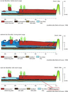
Bruns, Ines; Bungenstock, Friederike; Karle, Martina
Prehistoric storm surges in northwest Germany – record in the Holocene sediment sequence and effects on the un-diked coast Conference
41. Annual Meeting of the Working Group on Geography of the Seas and Coasts, vol. 41., Arbeitskreises der Geographie der Meere und Küsten NihK, ICBM, Wilhelmshaven, 2025.
@conference{nokey,
title = {Prehistoric storm surges in northwest Germany – record in the Holocene sediment sequence and effects on the un-diked coast},
author = {Ines Bruns and Friederike Bungenstock and Martina Karle},
editor = {Working Group on Geography of the Seas and Coasts},
year = {2025},
date = {2025-05-22},
urldate = {2025-05-22},
booktitle = {41. Annual Meeting of the Working Group on Geography of the Seas and Coasts},
volume = {41.},
pages = {1-36 | 6},
publisher = {NihK, ICBM},
address = {Wilhelmshaven},
organization = {Arbeitskreises der Geographie der Meere und Küsten},
abstract = {Since the beginning of the Holocene, the northwest German coast has been shaped by the rising sea level, resulting in a general progradational shift of the coastline. Accordingly, the Holocene sedimentary sequence comprises peat layers, brackish-lagoonal, and marine deposits. In addition to gradual changes, extreme events such as storm surges have contributed to coastal development and must be considered to better understand the region’s landscape evolution.
In contrast to the modern coast, which is strongly influenced by human-made constructions, the paleo-coast was un-diked. Therefore, it can be assumed, that prehistoric storm surges had different effects on the coastal environment at the time. Storm surge deposits have been documented along the East Frisian coast and the Ems-Dollard estuary. However, they have not been systematically investigated so far. The short-term and long-term effects of storm surges remain poorly understood. Key questions are: How far did storm surge waters inundate inland? Were certain areas especially prone to inundation and erosion? And might past storm surges have triggered transgressions?
The interdisciplinary project CoastAdapt addresses these questions through insights from sedimentological archives and paleo-landscape reconstructions. Our focus lies on thin (mm to cm) clastic layers embedded within Holocene peat horizons — known as Klappklei. These deposits form during severe storm events, when the seawater reaches coastal peatlands, causing the upper part of the peat to temporarily uplift and allowing fine-grained sediments to enter the resulting gap. As the peat resettles after the storm, the sediment becomes preserved, creating a clear, interpretable record of storm surge history.
We present a first overview of the spatial and temporal distribution of Klappklei deposits and associated inundation extent of prehistoric storm surges. These initial results are based on extensive analyses of borehole archive data, integrated with updated sea-level reconstructions for the northwest German coast. Preliminary insights also highlight areas that appear particularly vulnerable to inundation.},
keywords = {},
pubstate = {published},
tppubtype = {conference}
}
Since the beginning of the Holocene, the northwest German coast has been shaped by the rising sea level, resulting in a general progradational shift of the coastline. Accordingly, the Holocene sedimentary sequence comprises peat layers, brackish-lagoonal, and marine deposits. In addition to gradual changes, extreme events such as storm surges have contributed to coastal development and must be considered to better understand the region’s landscape evolution.
In contrast to the modern coast, which is strongly influenced by human-made constructions, the paleo-coast was un-diked. Therefore, it can be assumed, that prehistoric storm surges had different effects on the coastal environment at the time. Storm surge deposits have been documented along the East Frisian coast and the Ems-Dollard estuary. However, they have not been systematically investigated so far. The short-term and long-term effects of storm surges remain poorly understood. Key questions are: How far did storm surge waters inundate inland? Were certain areas especially prone to inundation and erosion? And might past storm surges have triggered transgressions?
The interdisciplinary project CoastAdapt addresses these questions through insights from sedimentological archives and paleo-landscape reconstructions. Our focus lies on thin (mm to cm) clastic layers embedded within Holocene peat horizons — known as Klappklei. These deposits form during severe storm events, when the seawater reaches coastal peatlands, causing the upper part of the peat to temporarily uplift and allowing fine-grained sediments to enter the resulting gap. As the peat resettles after the storm, the sediment becomes preserved, creating a clear, interpretable record of storm surge history.
We present a first overview of the spatial and temporal distribution of Klappklei deposits and associated inundation extent of prehistoric storm surges. These initial results are based on extensive analyses of borehole archive data, integrated with updated sea-level reconstructions for the northwest German coast. Preliminary insights also highlight areas that appear particularly vulnerable to inundation.3.
Bölker, Thea; Lojek, Oliver; Schweiger, Constantin; Goseberg, Nils
Analysis of coastal dune structure and vegetation patterns: An extensive field campaign on Langeoog Conference
41. Annual Meeting of the Working Group on Geography of the Seas and Coasts, vol. 41., Arbeitskreises der Geographie der Meere und Küsten NiHK, ICBM Wilhelmshaven, 2025.
@conference{nokey,
title = {Analysis of coastal dune structure and vegetation patterns: An extensive field campaign on Langeoog},
author = {Thea Bölker and Oliver Lojek and Constantin Schweiger and Nils Goseberg},
editor = {Working Group on Geography of the Seas and Coasts},
year = {2025},
date = {2025-05-22},
urldate = {2025-05-22},
booktitle = {41. Annual Meeting of the Working Group on Geography of the Seas and Coasts},
volume = {41.},
pages = {1-33 | 4},
address = {Wilhelmshaven},
organization = {NiHK, ICBM},
series = {Arbeitskreises der Geographie der Meere und Küsten},
abstract = {Coastal dunes provide a variety of ecosystem services, including biodiversity, freshwater supply, and storm surge protection, making them an integral part of coastal ecosystems. However, rising sea levels as well as changes in wave and wind conditions due to climate change are increasing the pressure on coastal systems. From an engineering point of view, the focus is on protection against storm surges, with dune erosion processes often being studied in physical experiments. To ensure a high reliability of the model, it is crucial to first capture the dunes as realistically and thoroughly as possible. Therefore, a field campaign in March 2025 on the East Frisian Island Langeoog, Lower Saxony, Germany is conducted aiming to provide valuable insight in the internal structure of the dunes and in the evolving vegetation patterns on the dunes. This campaign will involve a wide variety of measurements, employing both established and novel techniques. A drone survey will capture vegetation patterns, coverage and the topography of the dune landscape, by deriving digital elevation data through structure from motion. Additionally, a ground-penetrating radar (GPR) will be utilized to detect internal physical boundaries through the visualization of contrasts in electromagnetic properties to draw conclusions about the layering of the sediment, the moisture content, grain size, porosity and the presence of roots. Complementary measurements will be conducted to gather soil and vegetation parameters, aiding in the calibration and interpretation of the spatial data obtained from the drone surveys and the GPR. The study aims to identify potential correlations among the various measured parameters, as well as between these parameters and specific constraints, such as distance from and orientation to the shoreline, to enhance physical modeling. Preliminary results of the field campaign will be presented, accompanied by a discussion of their potential implications for future research and model building.},
keywords = {},
pubstate = {published},
tppubtype = {conference}
}
Coastal dunes provide a variety of ecosystem services, including biodiversity, freshwater supply, and storm surge protection, making them an integral part of coastal ecosystems. However, rising sea levels as well as changes in wave and wind conditions due to climate change are increasing the pressure on coastal systems. From an engineering point of view, the focus is on protection against storm surges, with dune erosion processes often being studied in physical experiments. To ensure a high reliability of the model, it is crucial to first capture the dunes as realistically and thoroughly as possible. Therefore, a field campaign in March 2025 on the East Frisian Island Langeoog, Lower Saxony, Germany is conducted aiming to provide valuable insight in the internal structure of the dunes and in the evolving vegetation patterns on the dunes. This campaign will involve a wide variety of measurements, employing both established and novel techniques. A drone survey will capture vegetation patterns, coverage and the topography of the dune landscape, by deriving digital elevation data through structure from motion. Additionally, a ground-penetrating radar (GPR) will be utilized to detect internal physical boundaries through the visualization of contrasts in electromagnetic properties to draw conclusions about the layering of the sediment, the moisture content, grain size, porosity and the presence of roots. Complementary measurements will be conducted to gather soil and vegetation parameters, aiding in the calibration and interpretation of the spatial data obtained from the drone surveys and the GPR. The study aims to identify potential correlations among the various measured parameters, as well as between these parameters and specific constraints, such as distance from and orientation to the shoreline, to enhance physical modeling. Preliminary results of the field campaign will be presented, accompanied by a discussion of their potential implications for future research and model building.4.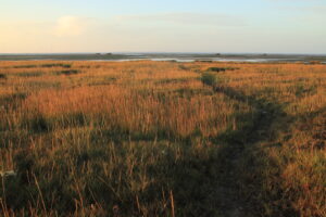
Hackett, Isabel; Goseberg, Nils; Schweiger, Constantin; Lojek, Oliver; Karle, Martina; Bungenstock, Friederike; Bruns, Ines
Influence of Shifting Land Management and Salt Marsh Vegetation Composition on Wave Attenuation Through the Late Holocene Conference
41. Annual Meeting of the Working Group on Geography of the Seas and Coasts, vol. 41., Arbeitskreises der Geographie der Meere und Küsten NiHK, ICBM Wilhelmshaven, 2025.
@conference{nokey,
title = {Influence of Shifting Land Management and Salt Marsh Vegetation Composition on Wave Attenuation Through the Late Holocene},
author = {Isabel Hackett and Nils Goseberg and Constantin Schweiger and Oliver Lojek and Martina Karle and Friederike Bungenstock and Ines Bruns},
editor = {Working Group on Geography of the Seas and Coasts},
year = {2025},
date = {2025-05-22},
urldate = {2025-05-22},
booktitle = {41. Annual Meeting of the Working Group on Geography of the Seas and Coasts},
volume = {41.},
pages = {1 - 33 | 12},
address = {Wilhelmshaven},
organization = {NiHK, ICBM},
series = {Arbeitskreises der Geographie der Meere und Küsten},
abstract = {Salt marshes are rich and diverse environments, which when functioning and protected, have the capacity to improve the health of both the terrestrial and marine environments they link. Along the North Sea coastline, and other areas vulnerable to storm surge floods and increasing sea levels, the wave attenuating capacity of salt marshes is of critical importance. Wave attenuation by salt marsh vegetation occurs through long term sediment accumulation and friction. In this study I analyze historical vegetation composition evidenced in sediment cores in the Krummhörn region along the North Sea coastline in Lower Saxony, in order to model salt marsh wave attenuation across varying periods of land-use and salt marsh extent. The prevalent species types, such as Juncus gerardii, Suaeda maritima, Salicornia europeae, and Spergularia salina, occupy distinct zones of the salt marsh and impact the tidal flow in differing ways. While sea level rise is currently accelerating faster than we have seen in the past 3,000 years of human history (Jelgersma, 1971), it is not a new phenomena, with the entirety of the Holocene epoch defined by rising levels. Analyzing the environmental history of the North Sea coastline allows us to consider future developments and potential paths towards more adaptable coastlines. With a focus on differing spatial extents and vegetation compositions, tidal damping under varying historical conditions will be modeled using Delft3D.},
keywords = {},
pubstate = {published},
tppubtype = {conference}
}
Salt marshes are rich and diverse environments, which when functioning and protected, have the capacity to improve the health of both the terrestrial and marine environments they link. Along the North Sea coastline, and other areas vulnerable to storm surge floods and increasing sea levels, the wave attenuating capacity of salt marshes is of critical importance. Wave attenuation by salt marsh vegetation occurs through long term sediment accumulation and friction. In this study I analyze historical vegetation composition evidenced in sediment cores in the Krummhörn region along the North Sea coastline in Lower Saxony, in order to model salt marsh wave attenuation across varying periods of land-use and salt marsh extent. The prevalent species types, such as Juncus gerardii, Suaeda maritima, Salicornia europeae, and Spergularia salina, occupy distinct zones of the salt marsh and impact the tidal flow in differing ways. While sea level rise is currently accelerating faster than we have seen in the past 3,000 years of human history (Jelgersma, 1971), it is not a new phenomena, with the entirety of the Holocene epoch defined by rising levels. Analyzing the environmental history of the North Sea coastline allows us to consider future developments and potential paths towards more adaptable coastlines. With a focus on differing spatial extents and vegetation compositions, tidal damping under varying historical conditions will be modeled using Delft3D.